Every year, a big part of what we do at Sunset Country involves planning and organizing the production and printing of the annual Sunset Country Travel Guide and Fishing Map. With the 2020 version, I have now worked on 21 guides so I know it inside and out. I'd like to share with you on how to best use the guide and map when planning your trip.
Whether it's your first trip or your 30th, the guide and map are useful tools to have when planning things and with this article, I'll provide you with a few shortcuts on how to best use the information, the directories and the maps we work so hard to prepare for you each year. I thought writing the article like a Question and Answer format would be most useful so here we go.
What is the purpose of the guide and map and why is it useful to have if you're planning a vacation to Sunset Country?
There are three main reasons we produce the annual travel guide and map each year:
- To show the many great outdoor vacation opportunities present in our region of Canada
- To provide a document you can use as a reference guide to locate lodges, resorts, campgrounds and other forms of accommodation.
- To show the location of retail and service businesses, local travel centers and related services.
The guide and map are intended to provide consumers with a key link to the tourism businesses in this part of Ontario and Canada.
What kind of accommodations are listed?
The guide covers all types of accommodations available within the region and the pull-out map shows where in Sunset Country these locations are located.
We use a color-coded system of dots to show our members on the pull-out map:
- Lodges, Resorts & Campgrounds (dotted in red)
- Remote Outposts (dotted in green)
- Hotels/Motels/B&Bs (dotted in pink)
- Houseboat Rentals (dotted in blue)
- Canoe Outfitters (dotted in purple)
In addition, the pull-out map shows the location of all the towns and cities in Sunset Country, major highway corridors, tourist information center locations, airports, and border entry points.

How are the listings structured in the main travel guide?
In the travel guide, we list the accommodations and other members in alphabetical order by the towns in Sunset Country that they are closest to.
- Each member has a picture and listing block highlighting what they offer.
- If they have an advertisement in the guide, the page # of the ad will be listed.
The Travel Guide also has several useful directories and lists including:
- A Canoe Outfitter's Directory (page 15)
- A listing of Ontario Parks operating within Sunset Country's boundaries (page 15)
- An average temperature grid by month (page 19)
- A list of major festivals & events (pages 74 & 75)
- A "distance to Sunset Country borders" chart listing how far some major cities are from Sunset Country (page 76)
- A page listing the location and contact info for the Travel Information Centres across the region (page 77)
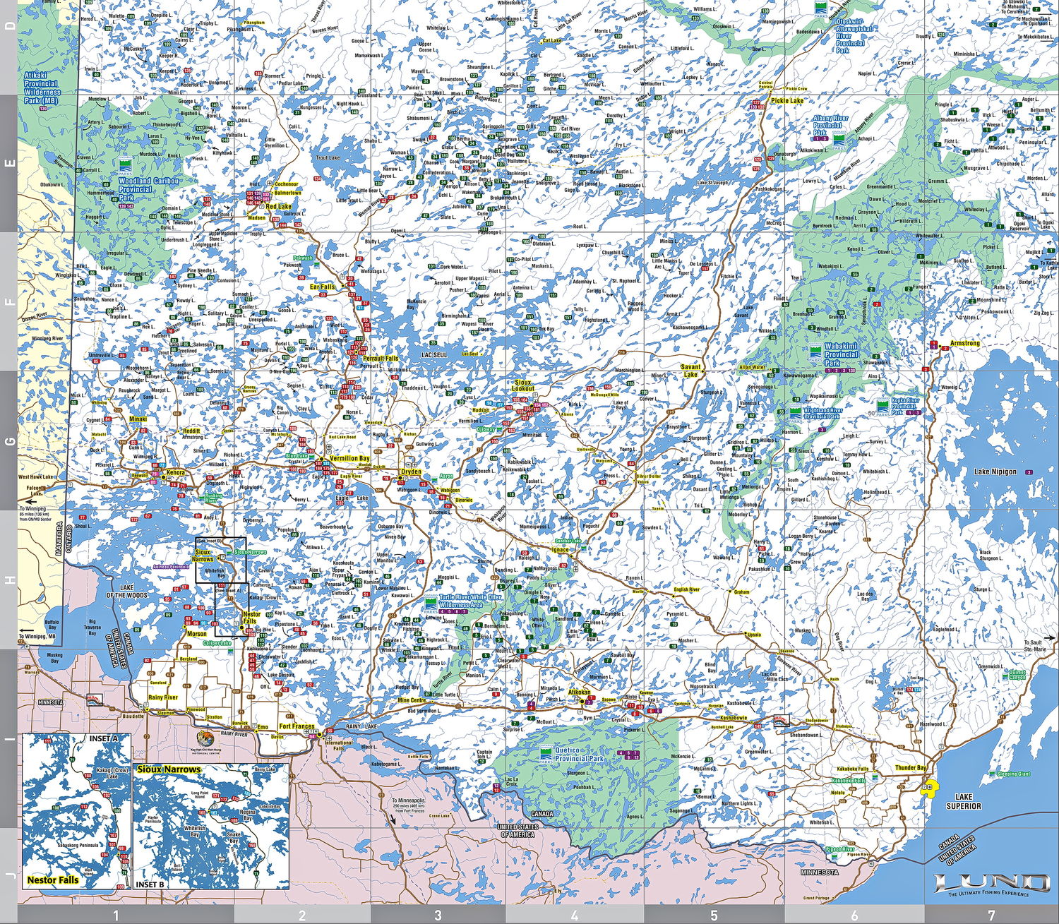
What information is on the map?
The pull-out map is 2-sided and is about the size of a movie poster. It's the "go-to" tool for planning any fishing trip up here.
Map side
Remember, Sunset Country covers an area of 70,000 square miles (100,000 square kilometers) - so it's a big map at 38 x 23 Inches
- Shows the physical locations of the Sunset Country lodges and outfitter members on a map of the region
- For ease of use, the map uses a grid system in conjunction with an alphabetical member list in the left side column
- Use the member list to find the member's dot number and grid location number(s) and then use the easy letter/number grid to locate them on the map area
- Member locations are color-coded by type with the member's listing # inside the dot
- The map legend explains the icons on the map
- The locations of the major border points of entry from the USA into Sunset Country - we are located north of the State of Minnesota
- Two areas with a high concentration of lodges (Sioux Narrows and Nestor Falls) are shown as insets in the bottom left corner of the map side
- The map also shows the location of all provincial parks, airports, and travel information centers
Listings side
There are three sections to the listings side of the pull-out map:
1. The Main Outfitter Directory listings are organized by rows and columns - the member's names are listed in alphabetical order by town/city in the rows with the what they offer shown by dots marked in the columns to the right. These columns identify:
- Access type (fly-in, drive-in, boat-in)
- Packages available (American Plan, Housekeeping, Outposts)
- The fish species available at their location(s)
- If they offer hunting, the animals species you can hunt at their location(s)
- Whether they offer houseboat rentals, canoe outfitting, family vacations or campground/RV sites
- Whether there are hotel/motel rooms for rent
- Whether the facility is open year-round (actually operating in the winter)
- Whether they offer wheelchair-accessible facilities
- The main outfitter directory listings also provide the contact information for the outfitter including:
- Summer & winter phone numbers
- Their website address
- Lakeshore they are located on (or street address)
- The page in the guide their ad is located on (if they have one)
Using the simple dots and columns system, you can quickly and easily explore what over 200 lodges and outfitters located in Sunset Country have to offer.
2. The Retail/Services Directory provides information on our retail and services business members so you can get the supplies you need while on vacation.
3. The Accommodation & Outfitter Alphabetical Directory is there for quick reference to find the map dot # of a lodge or outfitter using their business name
Order Your Free Guide and Map Here
Hopefully, this article will help you better use the map and guide to plan your next vacation. Remember if you want to speak with a Sunset Country representative in person you can call us toll-free at 1-800-665-7567 any time between 8 AM and 5 PM CT, Monday to Friday or email us here.
